|
|
Home →
Survival →
Navigation
Solar Navigation
Photos & Text by
Rob Bicevskis |
|
|
|
How do we tell direction from the Sun? Most of
us have observed that the sun rises more or less in the East and
sets in the West.
The question is, can we do better than this? Read
almost any book on survival, and there will be a number of
methods described for finding direction using the sun.
As with many things that are written in books, there are many
"borrowed" ideas. One person writes something, another
copies it, but changes it in a subtle manner, it gets copied
again etc. Pretty soon, a lot of the important data is
lost, or has been morphed into something that is no longer accurate.
Try searching the Internet for information on finding direction using
the sun. It would appear that there are some simple
methods to determine "exactly" the direction of N-S / E-W. According to "most" information that is "out there," some of the
favorite methods of finding direction include the Shadow Stick
and the Watch Method. I decided to try out these methods to see how will they work.
I also experimented with finding Longitude. The data for the following photographs was collected on July 19,
2005. (Location: N43° 27' W79°
51') The sun changes its angle in the sky on a daily
basis so the information presented here is one "snap shot."
At some later point in time, I may just sit down to do the math to predict
exactly how well these methods work for any day of the year.
For now, I will provide measured information so that the reader
might get a better "gut feel" for how these methods work. |
|
|
|
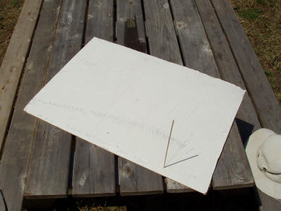 |
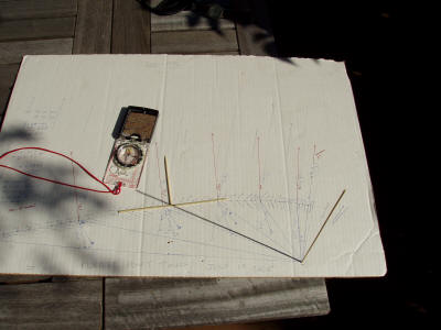
This was the
setup that I used.
A piece of cardboard with a bamboo skewer
inserted.
Every 5 - 10 minutes, I would mark the shadow
position.
|
|
|
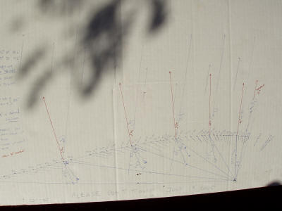 |
A closer view
of the plotted points.
(The other lines on the chart were drawn in for
measuring angles.) |
|
|
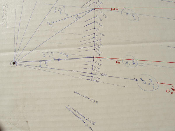 |
A closer
view, showing the plotted points. Note:
the times written on the chart were using DST. |
|
|
 |
Tangent/Perpendicular Method A "classic"
method to find direction is to plot two shadow
points and then draw a line between them.
This is claimed to be an E-W line, and the
perpendicular would then be the N-S line.
Since the sun's shadow moves in an arc (on most
of the planet), clearly this method has some error.
Many of the descriptions of this method imply
that the resultant direction is "absolute."
|
|
|
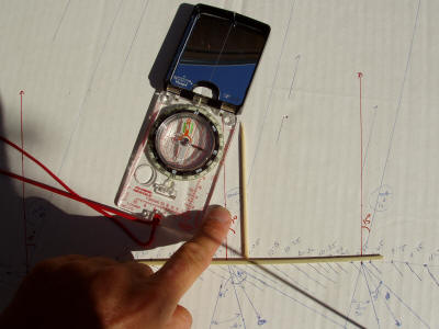 |
Here is a
close-up.
The pointers (sticks) show what is claimed to be
the cardinal points.
The compass (adjusted for declination) shows the
true N-S direction. Clearly there is error
here! |
|
|
|
| Time
(EST) |
Error from True North
(Degrees) |
| 7:00 |
23 |
| 8:00 |
20 |
| 9:00 |
17 |
| 10:00 |
15 |
| 11:00 |
8 |
| 12:00 |
4 |
| 12:20 |
0 |
|
This table shows the
approximate amount of error based on the method
described above. In the morning, we have the
greatest error, and it gets smaller as we approach
the solar noon.
Note that the error was only 0 at 12:20 - more on
that later when we discuss longitude. |
|
|
|
|
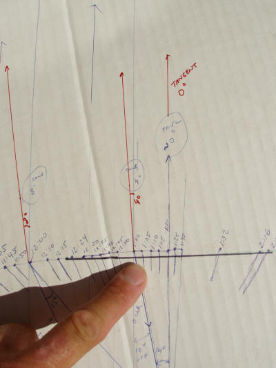 |
A more exact
method is to plot two points at equidistant times on
both sides of "noon." In this photo, the black line shows such a line.
The points plotted were on either side of "solar
noon."
Have a look at the discussion below about
longitude for an explanation of the difference
between "clock" noon, and solar noon.
|
|
|
 |
This black line pointed exactly W-E, and
the perpendicular line, N-S. Since the path of the sun is symmetrical around
solar noon, this method will always give true north.
The methodology is to plot a shadow point, then
wait until the shadow is shortest, then plot another
point an equal amount of time later.
|
|
|
|
|
 |
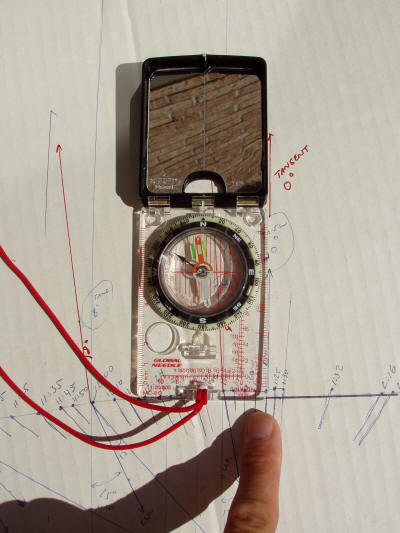
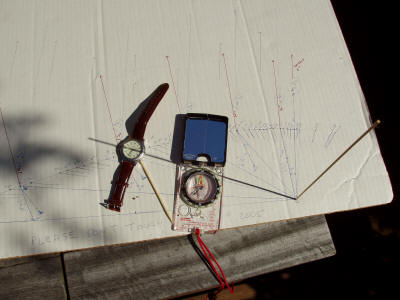
Watch Method
Another method of finding direction is the "watch"
method. The procedure is to point the hour
hand of a watch towards the sun. A line that
passes mid-way between the hour hand and the "12"
mark on the watch is supposed to point south.
The bamboo pointer shows where south should be by
this method.
|
|
|
 |
The picture
shows the same set-up, only this time using a normal
analog watch. Again the bamboo pointer shows
where south should be. The compass points to true north/south.
Look at the angle between the pointer and the
compass.
Clearly there is error in this method. |
|
|
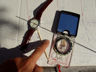 |
A close-up of
the error. Almost all of the references that I have seen for
this method make one think that it is exact.
|
|
|
|
| Time
(EST) |
Error from True North
(Degrees) |
| 7:00 |
35 |
| 8:00 |
30 |
| 9:00 |
30 |
| 10:00 |
30 |
| 11:00 |
25 |
| 12:00 |
12 |
| 12:20 |
0 |
|
How much error is there
in this method? The adjacent table shows what I
got on that day. There is certainly some
experimental error in my results, but one gets the
point. This is far from being an exact method.
Not only does this method have a large error, it
also
requires a watch. |
|
|
|
|
Longitude and some Theory There is a
lot of background in how our earth moves, and the
systems that we use to find out where we are, or
direction of travel. I will give a brief
introduction.
(Please put the words "more or less" in front of
just about everything that I am writing! I am
trying to describe the general principles - not the
exact science.)
Our earth rotates on it axis every 24 hours.
(Think about the more or less!)
We have defined there to be 360 degrees in a circle.
So, the earth rotates 360/24 or 15 degrees every
hour.
Longitude is our system for determining how many
degrees we are from Greenwich England (zero
degrees.)
At noon in Greenwich, the sun will be directly
overhead.
One hour later, it will be directly overhead a point
that is 15 degrees West of Greenwich.
If we were to give the longitude of this point, we
would say it is 15 degrees west - (kind of makes
sense doesn't it!?)
From this, we can see that time and degrees of
longitude are directly related.
Now a subtlety. It is "common" knowledge
that the sun is overhead (ie, at its highest
point) at noon. But
let's think about that one a bit.
Each time-zone is 15 degrees "wide" - or takes up 15
degrees of longitude. So, a person who sees
the sun directly overhead (ie, at its highest point) at one "edge" of the
time-zone means that someone at the other "edge" of
the time-zone will be seeing the sun 15 degrees off
from overhead. So the actual statement, is
that the sun is overhead within one hour of noon. How far off is determined by how far to
the East or West we are within one time zone - or
expressed another way, it is determined by our
longitude.
If we record the exact time that the sun is
directly overhead, we can do a bit of math and
figure out our longitude. How cool is that?
|
|
|
|
|
This is an enlargement of the shadow
plot. Notice the line that was drawn at 1:20.
This was the shadow that was cast that pointed
exactly to true north. If one doesn't have a
compass, it is also the "shortest" shadow. |
|
|
|
|
Let's do the math: First, we need to work in standard time.
The sun was directly overhead at 1:20 pm DST.
Converting to EST we get 12:20pm.
Since this was done in the Eastern Standard Time
Zone, we "know" that we are 5 time zones from
Greenwich.
Each time zone is 15 degrees, so our longitude is
5*15 = 75 degrees W plus a "bit."
How big is this bit? Well, solar noon (when
the sun was actually at its highest point in the sky) was at 20 minutes
past the hour.
20 minutes is one third of an hour - so we must be
one third of 15 degrees further West.
(20/60) * 15 = 5 degrees
So my longitude was 75 + 5 = 80 degrees West.
I took out my GPS and measured my actual
longitude to be 79 degrees, 51 minutes.
The error in my shadow plot resulted in an error
of only 9 minutes.
If we were to plot this difference on a map, then my
estimate of position was off by 6.7 nautical miles,
or 12.3 kms!
Pretty good for a stick, a piece of paper and a
watch!
(By the way, a nautical mile is equal to the
distance formed by one minute of longitude at the
equator.)
For more exact results with alternate methods, do
some reading on sextants. Conclusions and Notes
The data presented here represents one set of
numbers on one day of the year. The errors
will change with latitude and time of the year.
The watch/clock method, while sounding very cool
and exact is one of the worst methods to use.
Check the various available references - almost all
imply this method to be perfect, or very close!
The tangent/perpendicular method is pretty good
in the summer when the sun is quite high in the sky.
Towards winter, the sun will be lower and the shadow
will have more of a curve to it. Think about
whether this would make this method more or less
accurate.
Finding the solar noon sun - or shortest shadow -
will give an exact result, as will drawing a line
between two points that are plotted at times that
are the same amount before and after noon.
As for longitude - the real key is to have an
accurate watch. Given that these cost
about a dollar these days, who needs an expensive
GPS to find longitude!
--Rob |
|
|
|
|

